 |||
Home
Archives
Search
Feed
Gallery
Slottlr
RadioTowers-map
Digitised Books
Contacts
About me
World Map Maker
↑
|||
Home
Archives
Search
Feed
Gallery
Slottlr
RadioTowers-map
Digitised Books
Contacts
About me
World Map Maker
↑
If you need to make maps for illustrations or presentations then my map making tool might be useful for you. It’s adapted from an example provided by the people who make the ‘vega’ chart creation tool, obviously most of the credit goes to them.
This is a little bit about how it works, though most of the controls should be fairly obvious.
As you will see it consists of a canvas, at the top of the page where the map is drawn, and, underneath, a bunch of controls that affect different aspects of the map.
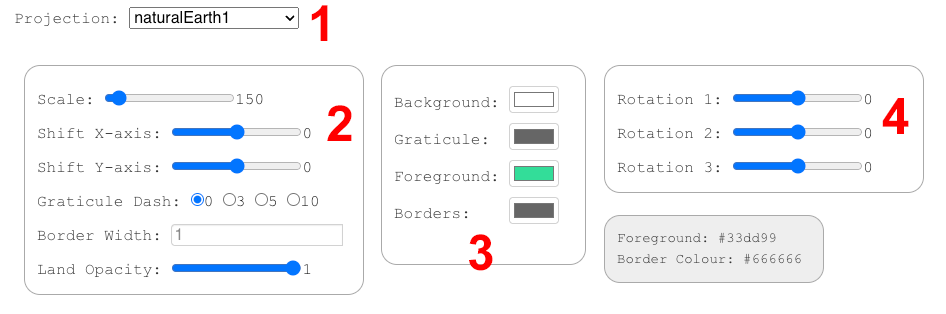 Diagram of map maker controls
 History of Cartography, vol.6
1 The first control allows you to choose a map projection - there’s no perfect way to project a globe onto a flat surface so these all have their pros and cons. Choose a projection that is appropriate for your purposes.
If you’re interested in understanding these pros and cons, there’s more than you could ever want to know about projections, and map-making in general, in the University of Chicago’s ‘History of Cartography’.
2 This area contains miscellaneous controls:
‘Scale’ controls the size of the map within the canvase, it’s the ‘zoom’ control,
‘Shift X/Y-axis’ controls the x-y position of the map image within the canvas,
‘Graticule Dash’ allows you to choose various dashed lines for the graticule, ie, the map grid,
‘Border Width’ controls the thickness of the country borders,
‘Land Opacity’, as you might expect, controls how transparent, or not, the land masses and borders appear.
3 These are the colour controls; ‘Background’ is the ‘sea/canvas’ colour, ‘Foreground’ the landmass colour. You also choose a colour for the ‘Graticule’ (grid lines) and the ‘Borders’ of the countries.
If you don’t want to see the borders I would suggest leaving ‘border width’ at ‘1’ and choosing the same colour for ‘Foreground’ and ’Borders. You can do this easily using the ’eye-dropper’ tool that appears in the colour chooser pop-up. If you know exactly what colours you need you can paste a value into the box in the ‘hex’ colour section of the pop-up.
4 These control various aspects of the ‘rotation’ of the maps you can make; their effect can be somewhat abstract — and vary across the different projections — so its easiest just to play with them until you get what you want.
It’s easy to miss but at the top right of the map canvas is a ‘…’ menu…
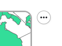 Export menu
This allows you to export your map to a PNG or SVG file. If you’re going to do further editing — eg. highlighting particular countries — I would suggest SVG. This can be opened in vector-graphic editing software such as the free (and fantastic) Inkscape, or Adobe Illustrator.
The ‘Supermap World’ site is also a good place to look for this kind of stuff; there are more projections on offer but you have to choose from a set of pre-created maps rather than designing your own.